

Miami River Episode 2 Then and Now
*If using a cell phone, hold phone horizontally for better view of photos


One can’t remain indifferent to the recent transformation in the landscape of the lower Miami River area. In the early 2000’s when I served as a young executive at one of the area hotels, unobstructed views were available in all directions. When we stood at the mouth of the river last week looking west, an urban canyon of modern high rises demonstrated the rapid change Downtown Miami has undergone. While we love reminiscing on the “good old days”, the modernization of the lower Miami River area brought a new river walk, restored some of its old sites and uncovered interesting and important archeological sites with information of the area history.
The north bank of the river was home to Henry Flagler’s Royal Palm Hotel between 1897 and 1930, Miami’s first luxury hotel. West of the Royal Palm were the Granada Hotel, Henrietta Apartments and Dallas Park Hotel that were demolished in the late 70’s to make place for the Downtown Convention Center and Hyatt Hotel. Today this area is home to modern luxury hotels and condominiums including InterContinental Miami, JW Marriott Marquis, The Epic Miami and more. (Pictures 1,2)
We parked our car in the municipal parking between Bayfront Park and InternContinental Miami. The boardwalk along the north bank of the river currently reaches a block west of the Second Avenue Bridge with two construction interruptions (approximately one mile). We walked along the boardwalk from the parking lot to Brickell Avenue Bridge, and then took the Bridge across the Miami River to the southern bank. Pay attention to the artwork as you cross the bridge. Cuban artist Manuel Carbonell was commissioned to create "The Pillar of History and the Tequesta Family", a 53 foot bronze monument with a 17 foot statue on the top commemorating the Tequesta Indians who resided in the area for close to 2000 years. At the supporting piers, 4 four by eight-foot bas-reliefs honor Miami’s modern pioneers and twelve bronze bas-reliefs of Florida fauna are located at the base of the flagpoles on the walkways of both sides of the bridge. (Picture 3)
As you reach the south end of the bridge, make a sharp left in front of the W Hotel and walk down to the Miami Circle on the bank of the River. The circle was discovered in 1998 during an archeological survey that was conducted prior to building a new luxury condominium tower. The surveyors found a limestone bedrock with hundreds of strange holes. Twenty four of the largest holes formed a perfect circle [thirty eight feet in diameter) believed to be the foundation of a ceremonial structure built by the Tequesta Indians. Archeological tests on artifacts found in the circle date them as being approximately 1800 years old. As we mentioned in our previous article, the Tequesta Indians lived along the river from approximately third century BCE until the establishment of the European settlements 2000 years later. (Picture 4) HistoryMiami, signed a 44-year lease on the site in 2008 and we suggest checking with the museum about walking tours of the area. ( citytours@historymiami.org)
A nice walk along the water on a good weather day is always recommended. Behind the First Presbyterian Church we found food trucks in case you forgot to bring your picnic basket with you.
We continued back to Brickell Avenue Bridge, crossed it to the north bank and went down to the board walk through a path between the bridge and the Hyatt Regency Hotel. A short walk west along the river we found what remains today of Historic Fort Dallas. The fort was established in 1836 as a US military post during the Seminole wars. It was also used by the US navy to prevent the Seminole Indians from trading with the Cuban merchants. The fort remained in Union Army hands during the civil war and was abandoned shortly after the war was over. In 1891 Julia Tuttle moved to the area with her family and bought the Land. She turned one of the old barracks to her residence. The old barracks were also used as slave housing in the local plantation prior to the establishment of the fort. Most of the structures were removed from the area to make place for housing developments. The barracks were disassembled and moved to Lummus Park less then a mile up the river. The only remaining structure is the Palm Cottage that was built by Henry Flagler in 1897 to house the workers constructing the Royal Palm Hotel. (Picture 5)
The river walk continues west for another hundred yards before it is interrupted again for an equal distance. We bypassed the blocked area by making a right under the Miami Avenue Bridge, left on South 4th Street and left again on Water Avenue through the new condominium development and back to the wonderful section of the boardwalk for another quarter of a mile.
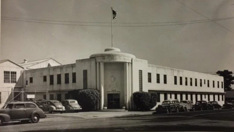
Across the river from the re-entrance point to the board walk is the Latitude Condominium building. Since the late 1890’s the area was used for shipbuilding. The most famous builder was Miami Shipbuilding Corporation that during world war two built the patrol torpedo boats PT-1 and PT-2 for the US Navy. In 1942 The company constructed a new administration building in the Art Moderne architectural style. Long after the shipyards went out of business, the administration building’s façade was featured in the television series Miami Vice as the headquarters of the Organized Crime Bureau. It was also featured in famous movies such as 1994 Sylvester Stallone’s “The Specialist” and 1995 “Bad Boys”. While the building was listed in the Historic Preservation District website it never received historic preservation protection and in 2004 it was razed to make place for the Latitude complex. The building can be identified by the popular eatery American Social on its waterfront ground level. (Pictures 6,8,9) Plan on spending two hours walking the tour.
As we were finalizing this episode, our good friend Harry Horgan, founder of Miami Shake A Leg, invited us to join him on a motorboat excursion up the Miami River (Miami Shake A Leg will be discussed at a future episode covering accessible activities on the bay). We certainly accepted his invitation and used the opportunity to take pictures of life along the river. As one sails further up the river, more spots of undeveloped early Miami can be found and we urge the readers to do the same if the opportunity arises, as modernization never falls asleep.
Recommendations for the lower Miami River walking tour
If you are in the Downtown area you can begin at any of the spots we discussed. The Downtown Metro Mover has stops at Bayfront Park, Brickell Avenue and Riverwalk Station. If you are in the Biscayne Corridor, you can take the Miami Free Trolley Biscayne Route to stations number 25, 26 or 40. You can also take the Brickell route to stations number 60, 64 or 69.
If you are driving to Downtown, the most convenient parking is between Bayfront Park and InterContinental Miami. Parking with Pay-by-phone app is $3.50 per hour.
Pack your picnic lunch in advance. There are plenty of benches along the Miami River to enjoy an outdoors lunch.
If you need a pit stop, you will pass by plenty of hotels with restrooms in the lobby.
For better viewing of the description written on each of the photos in this article, visit with a laptop, desktop, or tablet.
Join us soon for another article as we discover south Florida one backyard at a time.